

When we visited New Zealand, the pristine beauty of its landscapes had us mesmerised. We marvelled over the volcanic landscape of the North Island, and the glacial lakes and snowcapped mountains of the South Island. We discovered why this country is so popular - legendary - with hiking enthusiasts. It's diverse, show-stopping, and even on day hikes you can utterly immerse yourself in nature.
According to destination expert Philip Wyndham, the South Island is best for hiking - although he admits he's biased, given it's where he lives.
"What makes the best hike to me is a truly mountainous Alpine setting," he says. "I've been spoiled in spending a lot of time in the Himalayas and you can get that same Himalayan grandeur of views and epic mountains, of glaciers and ridgelines here in the South Island - but you can do from 800m (2,624ft) elevation, and there's not all the hassle and discomfort that high altitude brings.
"But the North Island is often overlooked - it has a lot to offer hikers. It has the volcanic central tablelands. It's got the greenery and the big rivers - and it's the volcanic story of the North Island, which often will dominate the hiking side of things. Whereas down here on the South Island it's just straight out Alpine passes, tussock country and glaciated lakes, and huge braided rivers."
You can get that same Himalayan grandeur of views and epic mountains, of glaciers and ridgelines here in the South Island
We've selected 10 of our favourite hikes across New Zealand, ranging from easy day hikes to multi-day 'tramps' (which is the local word for backcountry hiking. You'll come across it a lot!). In doing so, we've barely scratched the surface of what the country has to offer - but we hope we've given you a glimpse of its diversity, from its volcanic peaks to its mighty glaciers.
It’s important to note that these route descriptions are only short summaries, designed to inspire but not to serve any navigational purpose. They are not intended to guide you on the route and further mapping and planning will be required if you want to safely walk any of the trails featured.
5 of the Best Hikes on New Zealand's South Island
The South Island is renowned for its dramatic mountain landscapes. The Southern Alps, including the sky-piercing Aoraki/Mount Cook (3,724m/12,217ft) extend along the length of the island, and are bisected with deep valleys and covered with glaciers. Fiordland, in the south, is one of the island’s most dramatic regions - where the Southern Alps give way to ancient rainforest, where steep, glacier carved valleys lead down to glassy lakes.
Although the South Island is known for mountains, you mustn't forget about its beaches, from the windswept west coast to the golden coves of Abel Tasman National Park in the north.

When faced with the difficult task of choosing the best hikes in the South Island, we aimed to highlight this diversity. Our five top walks in the South Island will take you up mountains, into rainforests and past glaciers - sometimes in a single day. We’ve selected three day hikes and two of New Zealand’s iconic Great Walks, multi-day tramps through the country’s most spectacular scenery.
- Robert’s Point Track
- Hooker Valley Track
- Abel Tasman Coast Track (multi-day hike)
- Climb Ben Lomond
- The Milford Track (multi-day hike)
Below, you'll find a short description of the best hikes on the South Island.
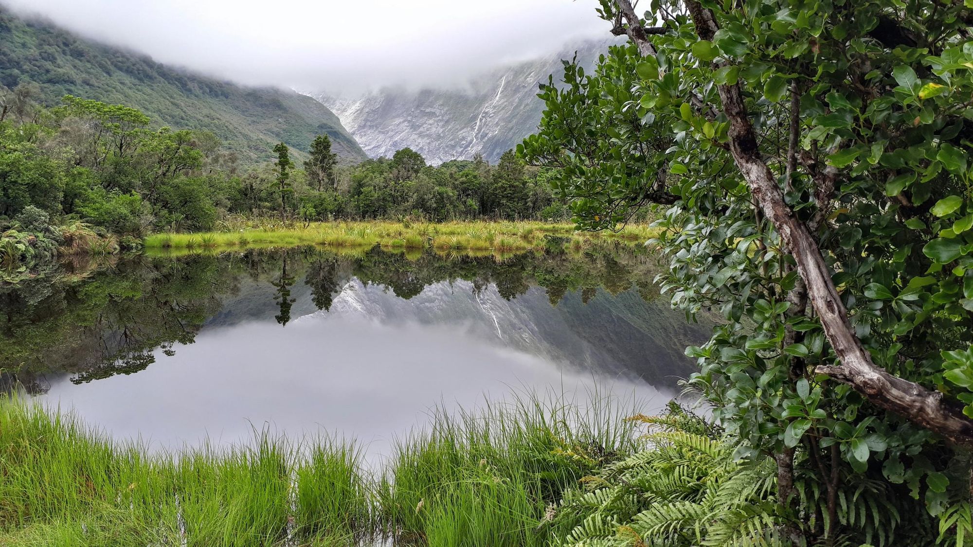
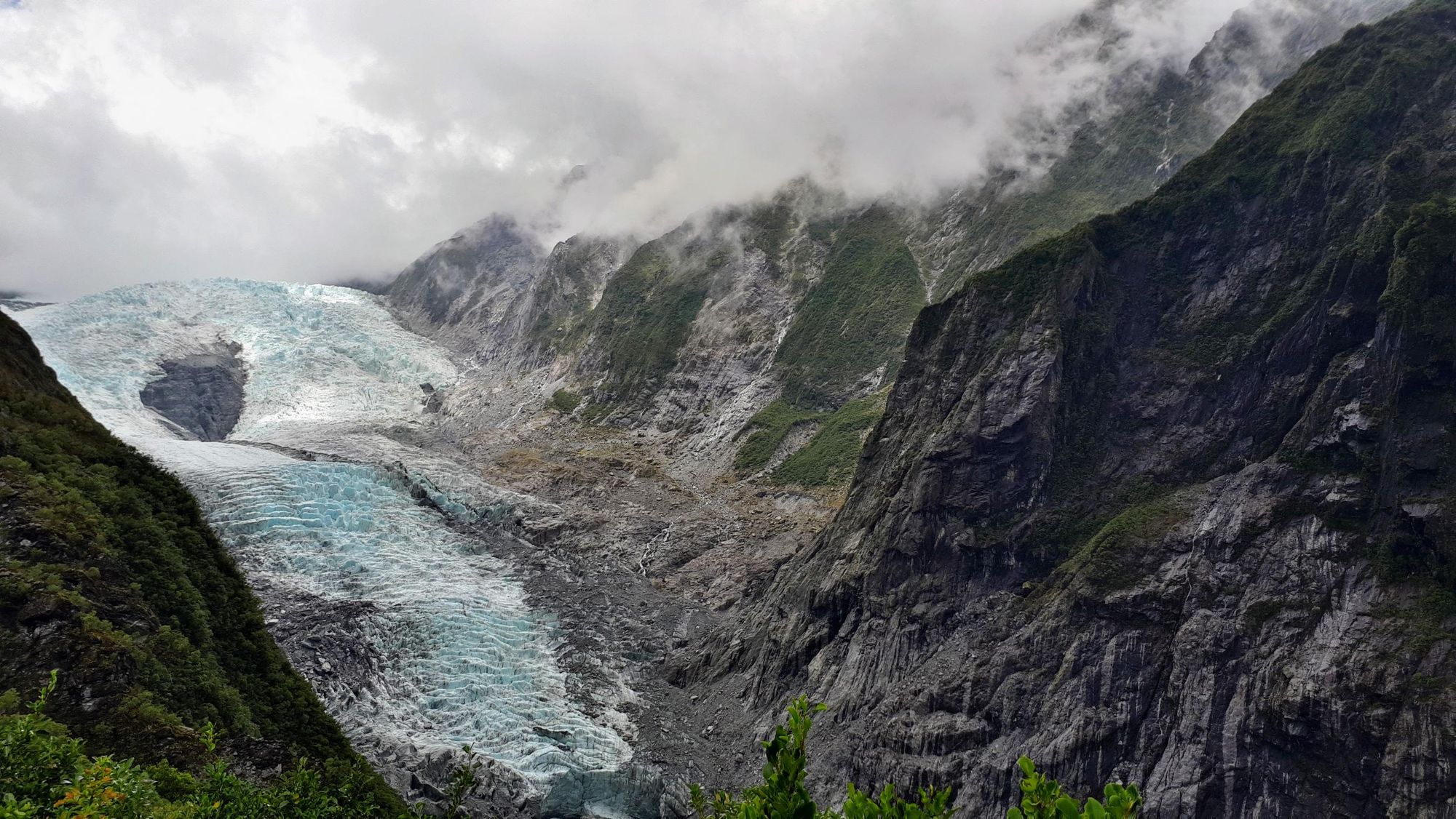
1. Robert’s Point Track
- Start/Finish: Franz Josef Glacier Car Park
- Distance: 7.6 miles (12.3km) out and back
- Walking time: 5-6 hours
- Difficulty: Challenging
- Best for: Glaciers, mountains and rainforest in a single day
A day hike in Westland Tai Poutini, which combines rainforest tramping with some fun light scrambling and an excellent view of the Franz Josef Glacier. Leave the car park and walk down a wide gravel trail through lush native rainforest. After around 500 metres you’ll reach a clearing where Peter’s Pool, a small kettle lake, reflects the mountains behind. You’ll continue past the pool, crossing the first suspension bridge of the walk over the vivid blue Waiho River.
The trail becomes less manicured as it winds upwards through the forest, crossing over a few small streams. After around 0.6 miles (1km) you’ll cross Rope Creek on a small, wobbly rope bridge. Here, the trail becomes rockier, with tree roots twisting across the path. Soon you’ll arrive at a 100m (328ft)-long suspension bridge - and as you cross it, you’ll have a stunning view of the surrounding mountains and waterfalls cascading down the rocky slopes.
After the bridge, the track becomes steeper, with sections requiring you to scramble up some rocky slabs. Tree roots make good handholds.
Eventually you’ll reach Hende’s Hut (a corrugated iron shelter built in 1907) - from here, ascend a wooden staircase attached to the clifftop. At the top of the staircase, the path levels out, before one final scramble. You’ll emerge onto Robert’s Point lookout platform, where you’ll be greeted by a breathtaking view of the Franz Josef Glacier sandwiched between two rocky peaks. Once you’ve enjoyed the view, it’s time to head back the way you came.
We underestimated this hike, believing that, due to the distance, it couldn’t possibly take five hours. It did - the path was steep and slippery after recent rainfall (which also swelled the small rivers you cross over), and some scrambling was required on the steeper bits. It’s nothing an experienced hiker won’t be able to handle, though - and the view from the lookout point is more than worth the effort.
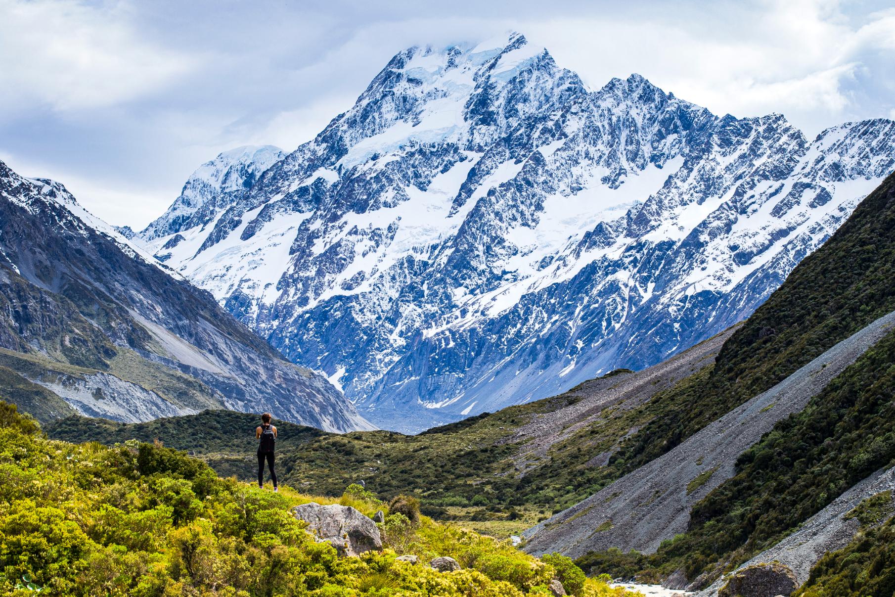
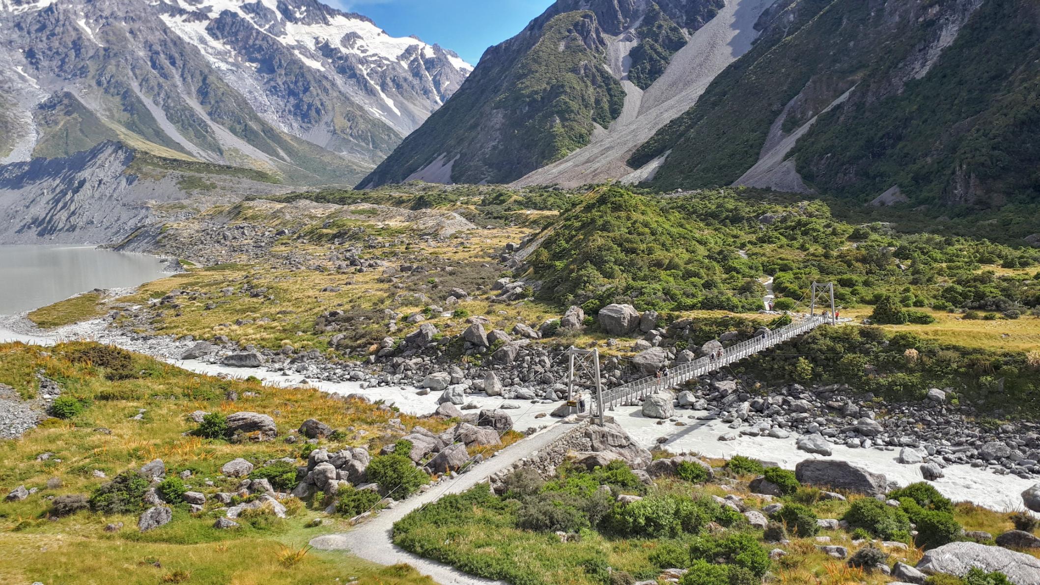
2. Hooker Valley Track
- Start/Finish: White Horse Hill Campground
- Distance: 6.2 miles (10km) out and back
- Walking time: 3 hours
- Difficulty: easy
- Best for: Mountain scenery without an uphill struggle
Aoraki/Mount Cook (3,724m/12,217ft) is the highest mountain in New Zealand, located in the Southern Alps. It’s a technically demanding mountain, which around 240 climbers have lost their lives to since 1907. We are not going to recommend you climb it. But what we are going to recommend is the Hooker Valley Track, which takes you right up to the foot of Aoraki/Mount Cook - offering views of this mighty summit, without the risk.
You’ll hike from the car park along a gravel track, which leads you through the sacred Tōpuni area of the Hooker Valley; glacial moraine encircled by the Southern Alps. On your left you’ll pass the Alpine Memorial, a stone pyramid dedicated to those who lost their lives in these mountains. After around a kilometre (0.6 miles) you’ll reach a lookout point over Mueller Lake, a milky blue glacial lake. Cross the Hooker River on the first of three swing bridges.
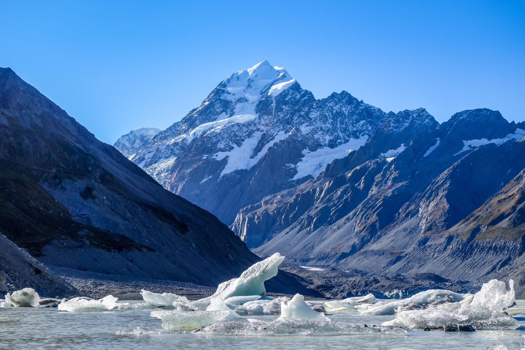
Continue along the track, which follows the curve of the lake over old moraine ridges and up several small steps to the second swing bridge. From here, the valley widens out, and becomes grassier - wooden boardwalks have been erected to take you over soggier ground. Once you’ve crossed the third and final swing bridge, the path leads up to Hooker Lake, with Mount Cook looming behind. The lake waters are studded with icebergs, which break away from Hooker Glacier, at the lake head. Sometimes, if you’re lucky, you can see this happen.
Because the walk is a relatively easy one, it gets popular. We’d recommend doing it early on in the day - even at dawn, so you can watch the sunrise over Aoraki. However, in winter, the track gets icy and high winds can howl through the valley - in adverse weather conditions, the track or swing bridges might be closed, so make sure you check the latest updates from the Department of Conservation.
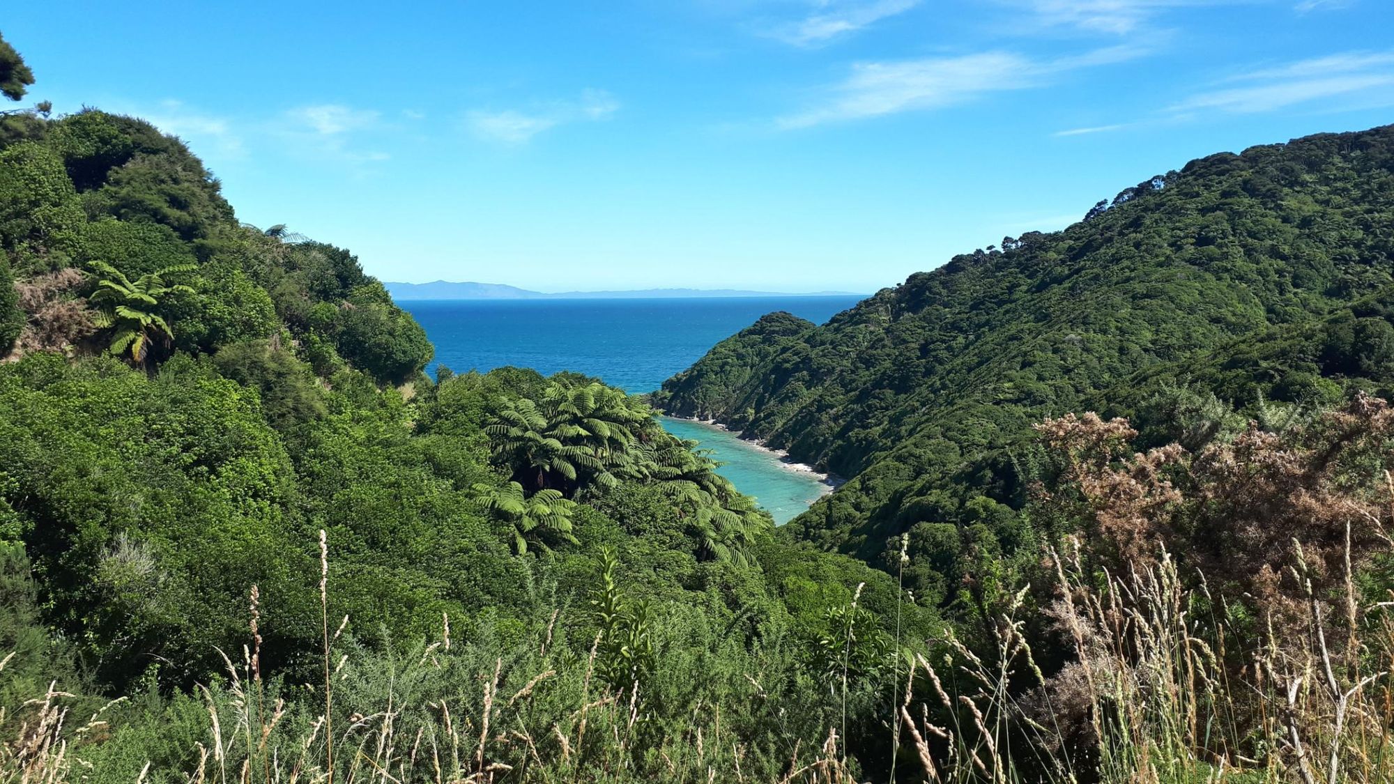
3. Abel Tasman Coast Track
- Start/Finish: Mārahau to Wainui
- Distance: 37.2 miles (60km)
- Walking time: 3-5 days
- Difficulty: Moderate
- Best for: Coastal rainforests and secluded beaches
Abel Tasman National Park hugs the South Island’s north coast; a landscape of golden beaches, forested hills and granite tracks. One of its most popular hikes is the Abel Tasman Coast Track, one of New Zealand’s Great Walks - a 37.2 mile (60km) route leading north from the Mārahau Estuary along the coast to Wainui.
The walk can be done in three days, but five days is recommended, as there are many possible side trips, including to the famous Awaroa Beach and Cascade Falls, a waterfall and natural pool hidden deep within the bush.
The first stage takes you across the Mārahau estuary to the secluded Tinline Bay, passing through beech forests and rounding headlands before finishing up on the white sands of beautiful Anchorage Bay. Stage two crosses Torrent Bay Estuary before winding up into forested hills, curving through two valleys before crossing a 47m (154ft)-long suspension bridge and descending through coastal forest to Bark Bay. Stage three involves a steep climb up to a forested saddle, with amazing views of Tonga Island and the clear waters of the surrounding marine reserve. Yu’ll end up at Awaroa Campsite.
The fourth stage takes you across the Awaroa inlet and past several bays, before climbing steeply to a lookout above Skinner Point before descending to Tōtaranui, then onto Whariwharangi Bay. The short final stage takes you through the coastal forest to Wainui Bay. From here, you can take a water taxi back to Mārahau.
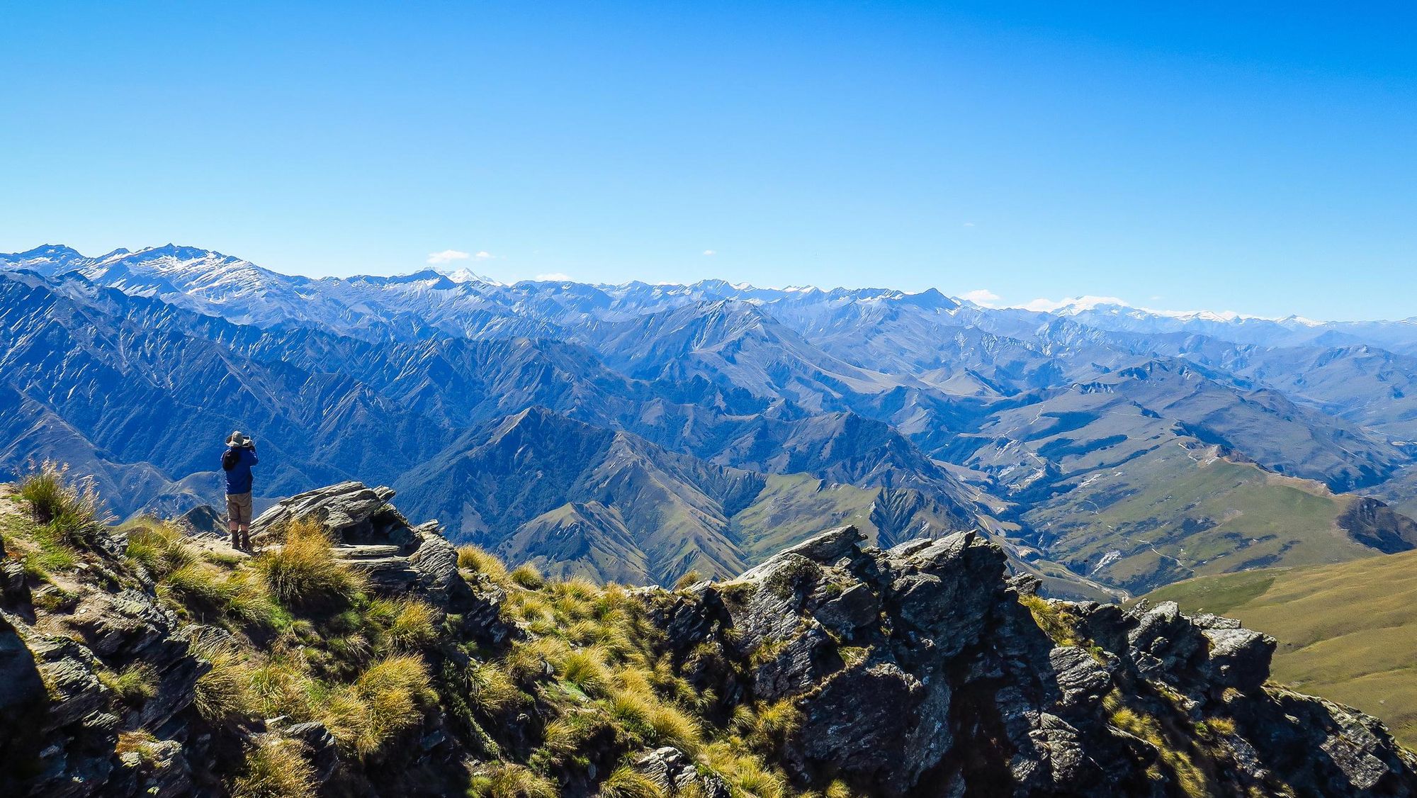
4. Climb Ben Lomond
- Start/Finish: Queenstown Gondola Base Station
- Distance: 8.6 miles (14km) out and back
- Walking time: 6-8 hours
- Difficulty: Challenging
- Best for: An easily accessible summit hike
This is one of the South Island’s most accessible mountain hikes - not to be confused with the Munro of the same name in Scotland. An ascent of Ben Lomond (1,748m/5,735ft) involves 1,438m (4,717ft) of elevation gain in a single day. The track begins at the gondola station, and winds up through Douglas fir forest on the Tiki Trail. At about 8,00m elevation you climb up above the treeline and hike through rough grassland to the Ben Lomond Saddle (1,326m/4,350m).
From here, the terrain becomes steeper and rougher. As you begin to climb up to the summit, the path becomes even steeper, with sharp drop offs. Eventually, you’ll reach the top, and on a clear day will be rewarded with views of The Remarkables range in the south east, alongside Lake Wakatipu and Cecil Peak in the south, and canyons and valleys to the north.
The accessibility of this hike makes it popular - and it’s often underestimated. During the winter months, the path can be snow-covered and the weather unpredictable. We’d recommend only experienced hikers undertake it. However, you can shorten the route by taking the gondola up to Top Station to start the hike - you’ll save yourself 450m (1,476ft) of ascent and descent.
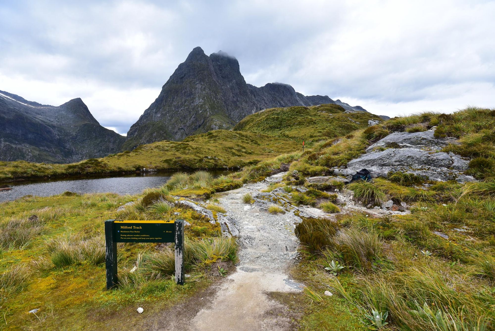
5. The Milford Track
- Start/Finish: Lake Te Anau/ Sandfly Point
- Distance: 33.2 miles (53.5km)
- Walking time: 4 days
- Difficulty: Challenging
- Best for: Immersion in the landscapes of Fiordland
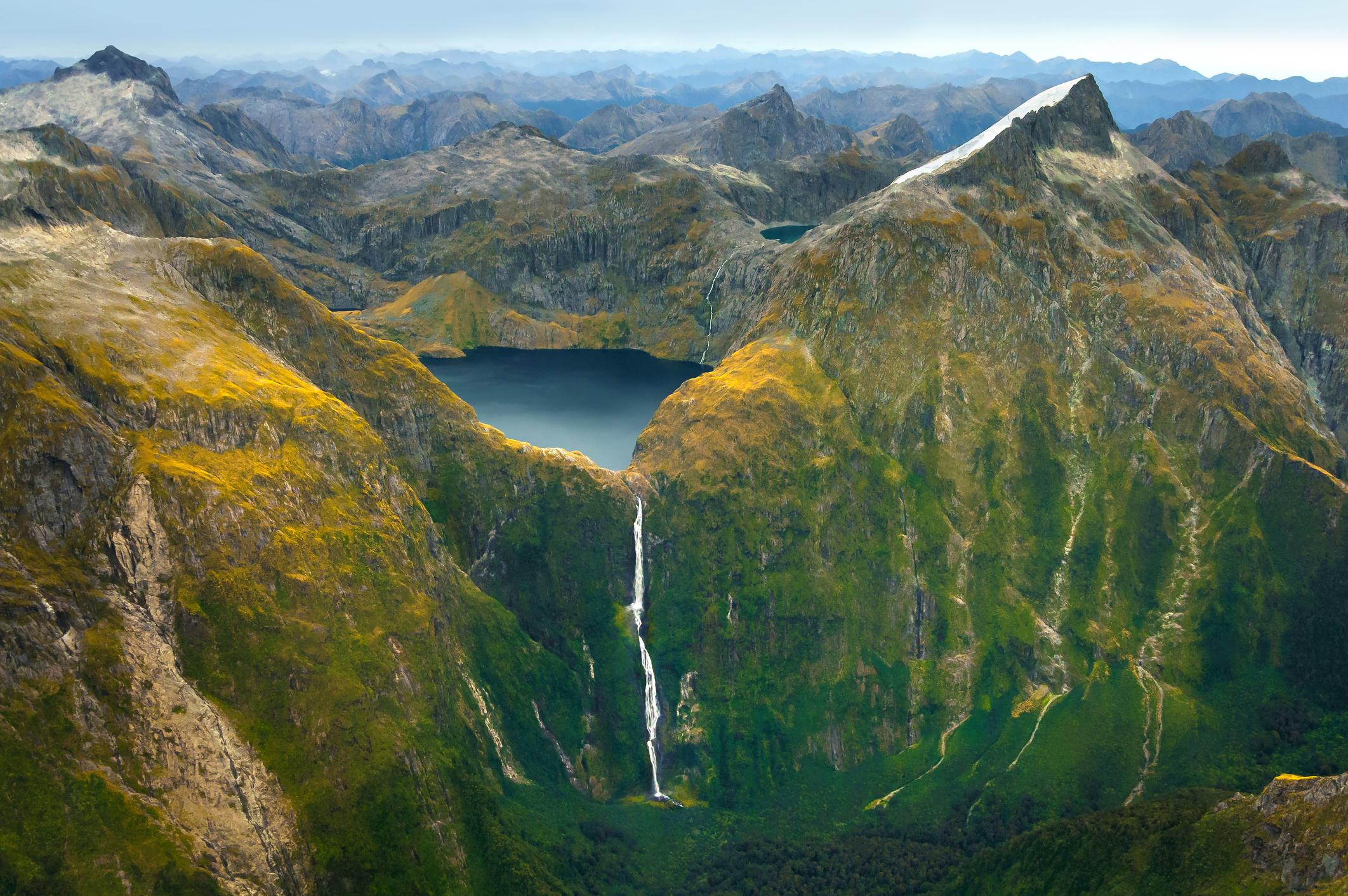
One of the most popular tracks in New Zealand (and another of the country’s Great Walks), the Milford Track leads through the heart of the Fiordland backcountry - a region of deep fjords, u-shaped valleys and mountains carpeted with rainforest. This is nature at its most wild and pristine, kept that way by restricting the number of hikers allowed on the trail to 40 a day.
To reach the trailhead, you’ll need to catch a boat trip across Lake Te Anau, from Te Anau Downs to Glade Wharf. From the wharf it’s a mere 90 minute walk through beech forest, along the banks of Clinton River to Clinton Hut, where you’ll spend the night. On day two you’ll climb up to Lake Mintaro, which is surrounded by steep mountains. Climb up the Clinton Valley, catching a glimpse of Pompolona Ice Field. You’ll sleep at Mintaro Hut (640m/2,099 ft).
Day three involves a steep climb to the top of Mackinnon Pass, the highest point of the hike at 1,154 metres (3,786 ft), where you’ll have panoramic views of the towering peaks and glacial valleys that characterise Fiordland. Descend to Dumpling Hut.
On day four, the track follows the Arthur River past the dramatic Mackay Falls. The track widens out for the last mile or so - it was constructed by a prison labour gang between 1890 and 1892 - and ends at Sandfly Point, where the Arthur River flows to Deepwater Basin. From here, you can catch a 20 minute boat ride to Milford Sound, where you’ll find buses back to Te Anau.
Camping is not permitted on the Milford Track - instead you must stay in the huts listed. During the Great Walks Season (October to April) these must be booked well in advance. During the winter (from May to October), heavy rain and snow make the path slippery and river crossings are required - only experienced mountain hikers should visit during this period.
5 of the Best Hikes on New Zealand's North Island
The North Island is often overlooked when it comes to hiking, or tramping if you prefer to use the New Zealand terminology. But just because the South Island of New Zealand might be more famed for adventure, doesn’t mean that the north doesn’t have a whole lot to offer too. On Mount Taranaki even the most adventurous will be challenged. On the Pinnacles Walk, you can reach remarkable views - and elsewhere, active volcanoes and steep coastlines await.
Looking to highlight that diversity, these are the five hikes we’ve selected as being the best walks on the North Island of New Zealand. Four are day hikes, while one is a multi-day endeavour.
- Climb Taranaki Maunga
- The Kauaeranga Kauri Trail (The Pinnacles Walk)
- The Tongariro Alpine Crossing
- The Te Pua-a-Tāne Circuit (multi-day hike)
- Cape Brett Walkway
Below you’ll find a short route description of each of these north island hikes.
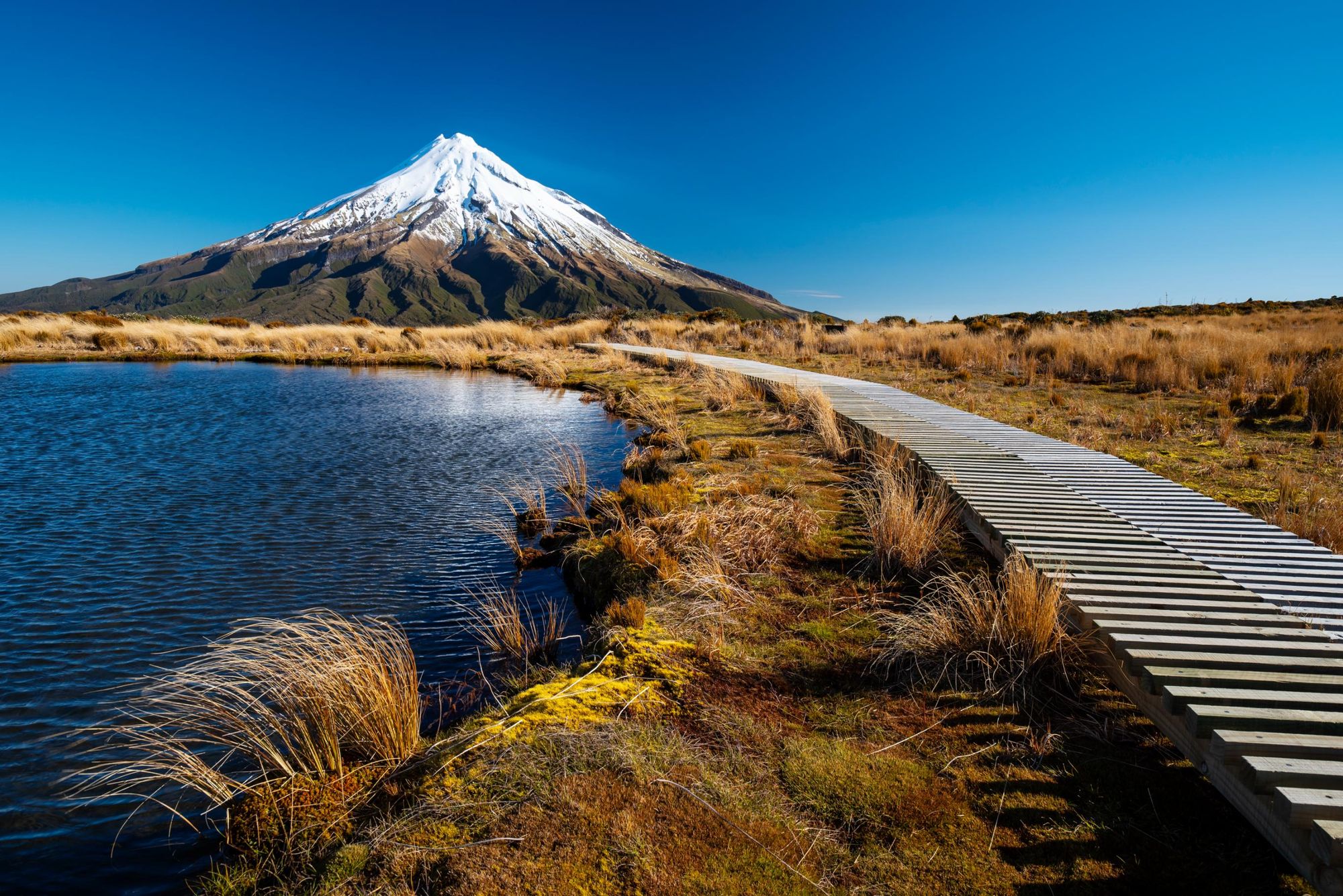
1. Climb Taranaki Maunga
- Start/Finish: North Egmont DOC Visitor Centre, out-and-back
- Distance: A 7.8 miles (12.6km) round trip
- Walking time: 8-12 hours
- Difficulty: Challenging
- Best for: A demanding, remarkable volcanic adventure
Mount Taranaki (in Egmont National Park) is a beauty of a mountain; perfectly triangular, standing high in isolation and with a snow-sprinkled summit looking out on lakes and coastline.
Walk on a clear, summer day, and you’ll find a wonderful route up to 2,158m (7,080ft) on a dormant volcano. Starting from the visitor centre at 936m (3,070ft), you’ll leave on a dirt track through forest, then cross moorland on your way to reach Tahurani Lodge at 1,492m (4,895ft). From here, it’s only 1.4 miles (2.3km) to the summit - but it’s steep, tough and stunning.
From here you head into a remarkable gully, where you’ll need to hike and scramble up to a staircase which guides you to a scree ridgeline, taking you to The Lizard - a section of tougher rocks at 2,134m (7,001ft). This section is as much a scramble as a hike, and can be vertigo-inducing.
It’s a couple of hours from here to the summit crater. From the top, you can look out over the west coast of the North Island, out to Mt Ngauruhoe and Mt Ruapehu in the centre, and over to the South Island. It is requested that hikers not stand directly on the summit stone of Taranaki, or camp or cook in the area, as the mountain holds spiritual significance for the local Iwi people.
Note that this hike is only achievable for hiking from January to April. From May to December, the mountain is covered in snow to a depth that mountaineering experience and equipment is required. Ask at the North Egmont DOC visitor centre for conditions before starting.
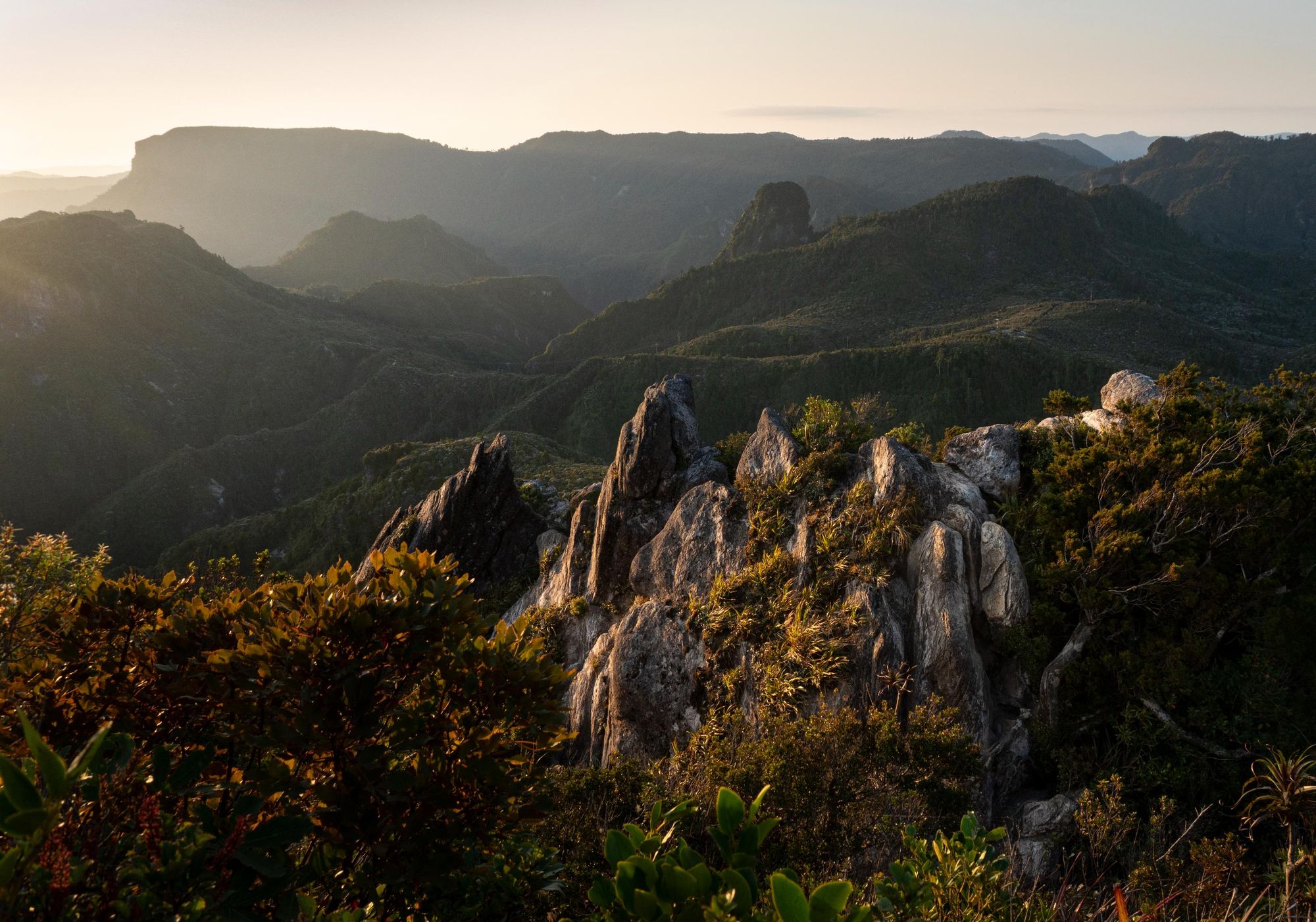
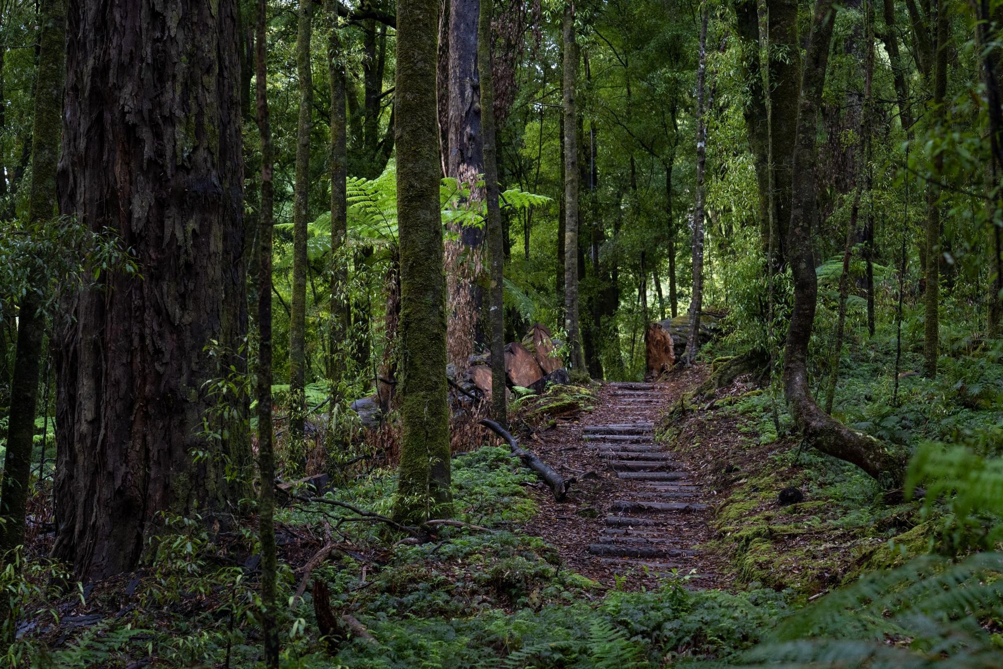
2. The Kauaeranga Kauri Trail (The Pinnacles Walk)
- Start/Finish: Kauaeranga Visitor Centre, out-and-back
- Distance: 9.3 miles (15km)
- Walking time:
- Difficulty: Moderate
- Best for: A year-round, immersive hike
If you think of Jurassic Park-style mist, mountains and untouched greenery when you think of New Zealand, then this is the hike for you.
This walk takes place in Coromandel Forest Park, guiding you on a flat gravel path and then ascending through the forest. There are some stone steps which were installed for pack horses and logging back in the day and plenty of turn offs. Follow the signs for Pinnacles Hut via Hydrocamp. The hut comes around two hours into the hike. From here, the hike gets more exposed as you climb up a staircase which weaves up the pinnacles.
After reaching the high saddle, there’s a short final section that involves ladders and rungs up to the summit. This section can be tough for those with vertigo, and shouldn’t be attempted in bad weather. It’s a 40-minute walk from the hut to the summit viewing platform, where you can look out over the Coromandel Peninsula; with rugged rocks coated in greens and rolling hills beyond.
To add an extra bit of bite to the trek, turn off onto the Billygoat Walk on your return leg. It’ll add an extra hour or so to the trek back and involves a river crossing.
For most people this is a day hike, but families also do this as an overnighter, staying in Pinnacles Hut (or at the campsite nearby). If you’re going to do this, book in advance.
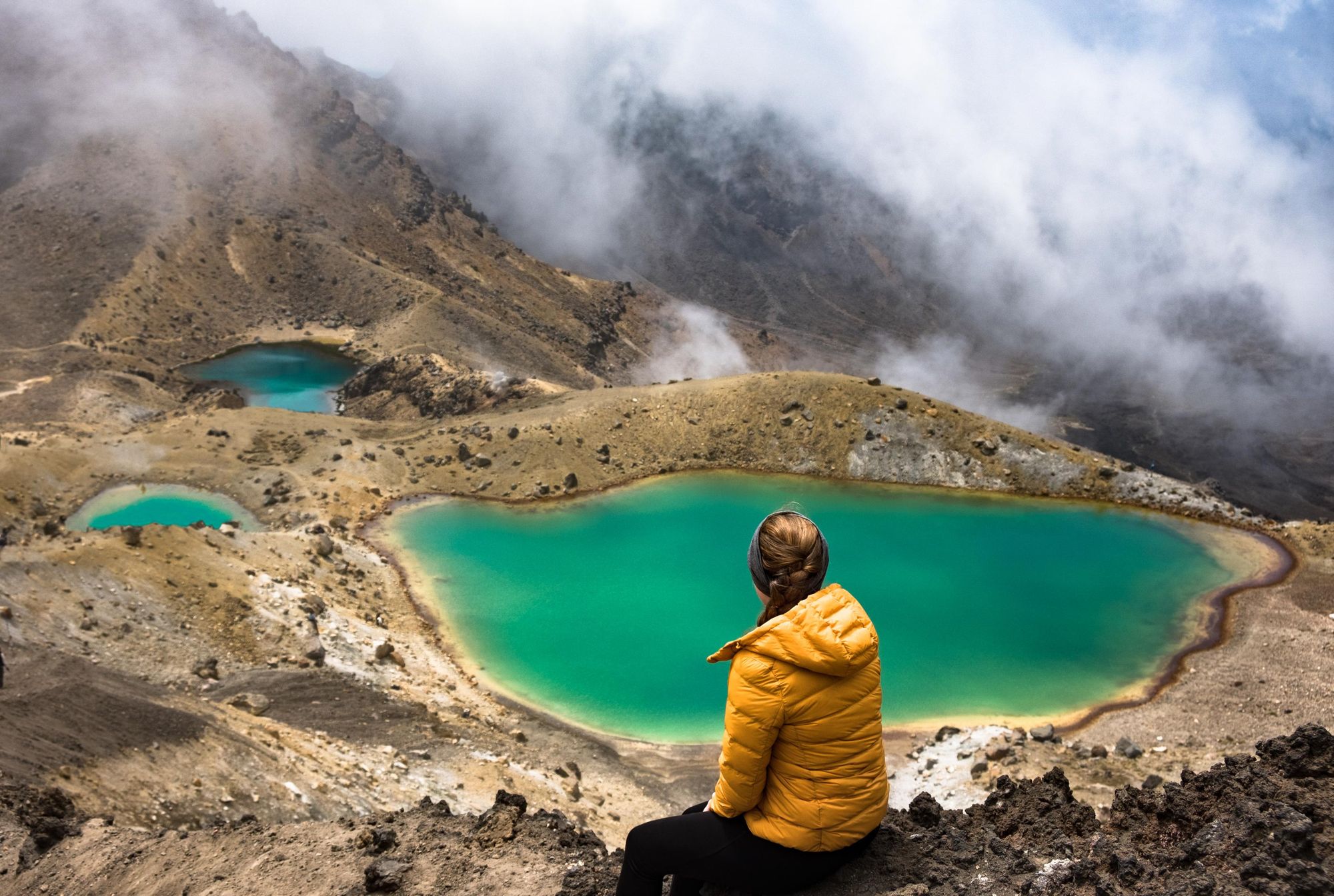
3. The Tongariro Alpine Crossing
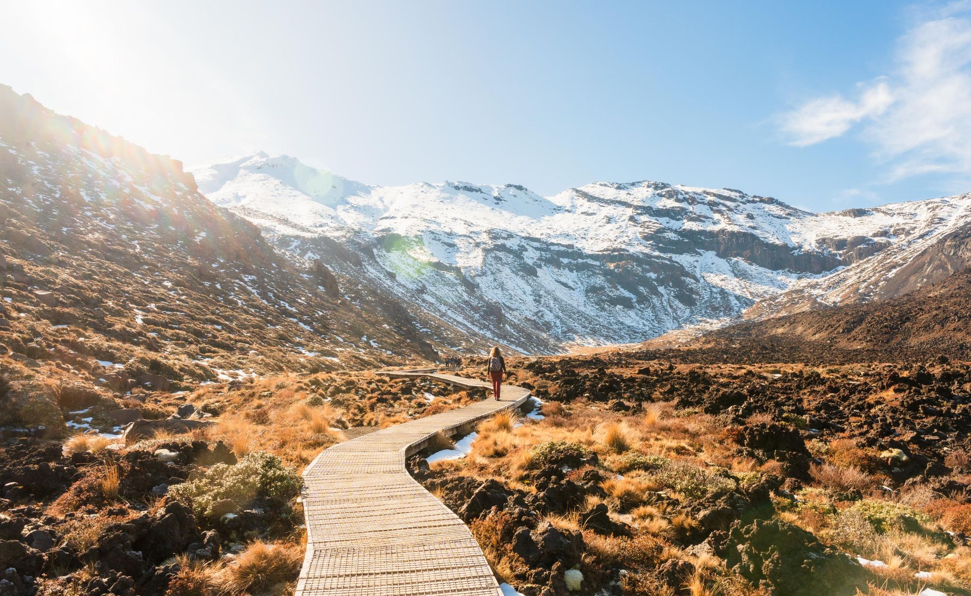
- Start/Finish: Mangatepopo Carpark to Ketetahi, point to point
- Distance: 12.1 miles (19.4km)
- Walking time: 7-9 hours
- Difficulty: Challenging
- Best for: Mixing volcanic grandeur and backcountry beauty
This big day hike mixes otherworldly volcanic scenery, colourful lakes and alpine landscapes. You’ll climb and descend an active volcano (Mount Tongariro, 1,978m/6,490 ft) - and feel like you’re moving between continents.
The route begins with a gentle climb on a boardwalk to Soda Springs. This section isn’t challenging, but the landscape is already remarkable, with vast plains and the mountains rising high around. From here, you’ll ascend to South Crater, take a stroll to Red Crater, and then ascend an exposed, steep ridgeline which guides you to the high point of the route - looking out over the spectacular, surrounding landscape.
From here, you descend to Emerald Lakes, which are as colourful as the name suggests. There are steam vents in this area (and the ground around them can be unstable), so stay on the track, leading you to the sacred Blue Lake, a stunning spot surrounded by volcanic rock. From here, it’s a 6.2 mile (10km), three-hour descent to Ketetahi, taking you down 1000m in altitude with expansive, far-reaching views over lakes and mountains.
Note that there are more search and rescues on this route than on any other in New Zealand, so come prepared with proper gear and ensure that you’re confident in navigational terms.
4. The Te Pua-a-Tāne Circuit
- Start/Finish: River Road Car Park, loop
- Distance: 49 miles (78.7km)
- Walking time: 5 days
- Difficulty: Challenging
- Best for: A hut-to-hut forest hike
The Whirinaki Te Pua-a-Tāne Conservation Park is home to the Ngāti Whare Māori tribe, as well as specially-protected native prehistoric forest. This circuit will take you through much of it - while making use of the conservation area’s superb network of low-cost huts.
Day one will take you from the car park to Vern’s Camp, the site of an old track cutter’s camp, and on to Central Whirinaki Hut, which has 25 bunk beds. The next stage runs to the Upper Te Hoe Hut, forking before the Taumutu Bridge, while the third stage runs to Mangakahia Hut, crossing the Te Hoe suspension bridge for lunch, then backtracking across it later. The route concludes with a climb over a saddle, with the trail then following Moerangi Stream to reach Moerangi Hut on day four, then concluding by returning to the River Road carpark - though not before a notable climb up and over the Moerangi saddle (955m/3,133ft) and a walk through podocarp forest..
The park is home to stone pines, North Island ironwood (known as rātā to the Maori), as well as to fern trees, to rimu resin yew and a plethora of other varieties which combine to form a rainforest. You’ll see geckos nipping around the trees, and possibly some less familiar species. A newly-discovered lizard called the Whirinaki Skink was found here as recently as 2003.
5. Cape Brett Walkway
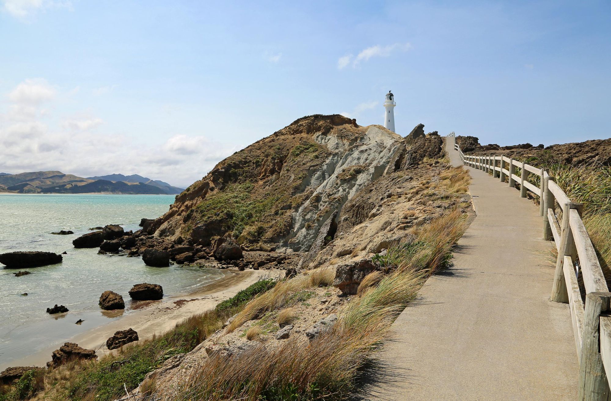
- Start/Finish: Oke Bay, out-and-back
- Distance: 20.5 miles (33km)
- Walking time: 7-9 hours
- Difficulty: Challenging
- Best for: Dramatic coastal Views
This big tramp across the island is one of the best ways to discover the far north of New Zealand’s north island. Starting in Oke Bay, the route runs just over 10 miles (16.5km) each way, and features rugged, remarkable coastal views, big cliffs with sheer drop-offs and native bush.
You’ll walk on Maori-owned land, along fantastic, forested ridges and out to superb coastline.
The final stretch of the hike runs from Deep Water Cove to Manawahuna on conservation land. This segment of trail is quite exposed, with some remarkable drop-offs over the edge of the trail.
You’ll reach an old lighthouse which marks the end of the trail, with views out to the outer Bay of Islands, as well as to Cavalli Islands to the north and Whangaruru and the Poor Knights Island to the south. Take in the coastal views, looking out for dolphins, then retrace your steps.
You can also actually stay at the lighthouse keeper’s house. Book in advance to do so.
Inspired? Check out our adventure holidays in New Zealand now!
Article written by Dani Redd and Stuart Kenny.